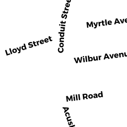
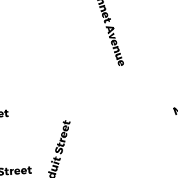
0014 CONDUIT STREET
Owner Information
HOPKINS DENNIS R & CINDY LOU
14 CONDUIT STREET
ACUSHNET, MA 02743


Property Details
0014 CONDUIT STREET is classified as a Single Family Residential (Old style).
The primary structure on this property was built in 1969. There are 1,144ft2 of built area within this property. There is 1,144ft2 of residential/living space within this property. This property is listed as having 6 rooms.
0014 CONDUIT STREET is valued at $200,500. The land is valued at $76,900 and the structures are valued at $123,600.
The most recent deed for 0014 CONDUIT STREET is recorded at the local registrar in Book 3358, Page 323. 0014 CONDUIT STREET was last sold on Wednesday, September 7, 1994 for $54,000.
Assessment data from fiscal year 2021.
Flood Data
According to the FEMA National Flood Hazard Layer, this property does not appear to be in a flood zone. It may also be in an area not yet reviewed. Nonetheless, confirm this information prior to taking any action.
To view the flood hazards around this property, create a FEMA "Firmette" Map of the area around 0014 CONDUIT STREET.
Broadband Internet Providers
| Provider | Type | Bandwidth (mbps) | |
|---|---|---|---|
| VSAT Systems, LLC. | Satellite | 2 | 1 |
| HughesNet | Satellite | 25 | 3 |
| Verizon New England Inc. | DSL | 15 | 1 |
| Viasat Inc | Satellite | 35 | 3 |
| GCI Communication Corp. | Satellite | 0 | 0 |
| Comcast | Cable | 1000 | 35 |
Broadband service provider data from December 2020.
Adjacent Properties
- 0010 CONDUIT STREET
Warehouses for storage of manufactured products owned by M-V MANAGEMENT, INC. - 0005 WILBUR AVENUE
Single Family Residential owned by ALLAIN JO-ANN - 0004 MYRTLE AVENUE
Mobile Home (includes mobile home park land) owned by MELLO LINDA J & VENCELO - 0010 MYRTLE AVENUE
Single Family Residential owned by PEIRCE ARTHUR S & PATRICIA